| About TPARC |
| Network Map |
| Services |
| Network How-to |
| Node Hardware |
| Membership |
| News |
Some documents linked from this page may require Adobe Acrobat PDF reader.
Last Updated August 2, 2021
Telephone Pioneers Amateur Radio Club
TPARC Network Map and Sites
Nearly all of TPARC's sites are co-located in existing TELUS facilities. We are very greatful for the support we have received from TELUS that allows us to provide this service to a number of communities in BC.
Switch Overview
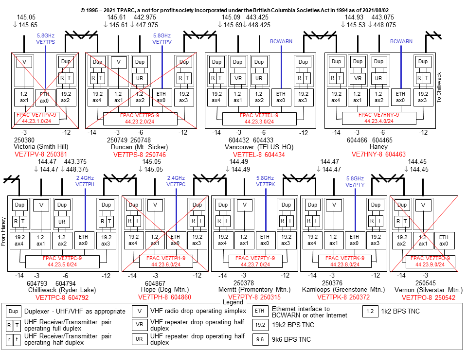
Network Map
EXTENT
RED T
Services at this site have been discontinued.
RED T
Services at this site have been discontinued.
RED T
RED T
RED T
RED T
Services at this site have been discontinued.
RED T
RED T
RED T
Services at this site have been discontinued.
Smith Hill/Victoria N48 26 45 W123 21 08
Services at this site have been discontinued.
Information retained for historical purposes.
Located in Victoria, the capital city of British Columbia,
on a knoll overlooking the city. Due to the
closeness to the US border, the antenna array was designed
to aim in a northerly direction.
Victoria was linked via UHF trunk to Duncan.
More info on Smith Hill.
Services at this site have been discontinued.
Mt. Sicker/Duncan N48 51 39 W123 45 24
Services at this site have been discontinued.
Information retained for historical purposes.
The city of Duncan lies at the bottom of Mt. Sicker (to the
East). Once owned by Telus (formally BC Tel), Mt. Sicker was
sold to the federal government and used as a
Doppler weather radar site. In 2017, the radar suffered a major hardware failure, and was decommissioned in 2018, and the site demolished. TPARC equipment was moved in with other users in another site.
This site is not accessible during poor winter conditions. Our
Duncan site has both a VHF simplex drop as well as a UHF digital
repeater.
The UHF trunk looked south to Victoria and east across the water
to the Headquarters building in Burnaby (Vancouver site).
More info on Mt. Sicker.
Services at this site have been discontinued.
Headquarters/Burnaby N49 13 58 W123 01 21
Also know as the "Boot" due to its unusual shape. The Headquarters building
was the first radio site for the TPARC, and is the Corporate Headquarters
for TELUS Communications.
It was here that the joint Totem/TPARC club voice repeater was established.
This was the first known joint venture in the Pacific Northwest.
Totem club members allowed the TPARC repeater to use the frequency used by the
Totem club.
This site was also the second packet site, and is still used to test new
equipment and concepts. Several TPARC members worked at the "Boot".
The Headquarters site UHF trunk faced west to Duncan and east to Haney. Due to construction in Metrotown, the UHF trunk to Haney was decommissioned in the 2010's.
More info on The Boot.
| FPAC NODE: | |
| Callsign: | VE7TEL-8 |
| ROSE Address: | 604434 |
| VHF Drop: | 145.090MHz +600kHz |
| ROSE Address: | 604432 |
| Speed: | 1200 baud (with repeat) |
| UHF Drop: | 443.425MHz +5MHz |
| ROSE Address: | 604433 |
| Speed: | 1200 baud (with repeat) |
| VHF Voice: | 145.170MHz -600kHz |
| Callsign: | VE7TEL |
| UHF Voice: | 442.875MHz +5MHz |
| Callsign: | VE7TEL |
Haney N49 12 00 W122 30 43
This site is located on the south slope of a small mountain overlooking
the Fraser River. One of the busiest sites due to its coverage from most
parts of Vancouver to much of the Fraser Valley.
This was the first packet site established.
The Haney trunk looks west to the Headquarters (Vancouver) site and east to Chilliwack.
More info on Haney.
| FPAC NODE: | |
| Callsign: | VE7HNY-8 |
| ROSE Address: | 604463 |
| VHF Drop: | 144.930MHz +600kHz |
| ROSE Address: | 604466 |
| Speed: | 1200 baud (with repeat) |
| UHF Drop: | 443.075MHz +5MHz |
| ROSE Address: | 604465 |
| Speed: | 1200 baud (with repeat) |
Ryder Lake/Chilliwack N49 06 52 W121 54 12
Situated on the north face of a mountain, with the city of Chilliwack to
the northwest, and the Fraser Valley at it's feet, this site serves the
mainly farming community with it's emergency communications.
The Chilliwack trunk faces Haney in the west and faced Hope in the northeast.
More info on Ryder Lake.
| FPAC NODE: | |
| Callsign: | VE7TPC-8 |
| ROSE Address: | 604792 |
| VHF Drop: | 144.470MHz Simplex |
| ROSE Address: | 604793 |
| Speed: | 1200 baud |
| UHF Drop: | 443.375MHz +5MHz |
| ROSE Address: | 604794 |
| Speed: | 1200 baud (with repeat) |
Dog Mountain/Hope N49 24 35 W121 33 28
Services at this site have been discontinued.
Information retained for historical purposes.
One of the most difficult sites to visit and maintain. This site sits at an elevation
of 4954 feet or 1,510 meters above sea level.
Because it is at the end of the flat valley floor, and is the first mountain range the
westerly pacific weather will encounter, weather conditions can be among the worst in
North America. Warm moist air rises quickly only to freeze on every structure it
encounters at elevation. This makes for extremely hazardous conditions.
Every antenna component has to be designed to withstand the tremendous amounts of ice
and snow that builds up.
Site access is only by cable car or helicopter (weather dependant). All equipment must
be small enough to be hand loaded onto the cable car, or paid for to be flown up.
Because of its unique nature, many photographs have been dedicated to this site. Our
Hope site overlooks the Fraser River and the Trans Canada highway to the south and the
town of Hope to the southeast.
In the late 2010's, TELUS started the decommissioning process for this site. In July
2021, power was turned off (after a previous Hydro failure, and generator failures).
The trunks looked at Chilliwack to the southwest and at Merritt to the north.
More info on Dog Mountain.
Services at this site have been discontinued.
Promontory Mountain/Merritt N50 11 45 W120 58 18
The city of Merritt lies at the east foot of Mt. Promontory.
This was not a designed path on the TELUS radio system, so this route does
create some difficulties in maintaining a digital radio link. Very heavy snowfalls
have been known to diminish the signal enough to drop the link.
The radio path is technically obstructed by a mountain, but there is enough knife-edge diffraction
to make the path work.
Our Merritt site cannot be reached for several months during the winter without
the aid of heavy tracked equipment (snowcat's) or, weather permitting, by helicopter.
Trunks from this site faced Hope to the south and face Kamloops to the northeast.
More info on Promontory Mountain.
| FPAC NODE: | |
| Callsign: | VE7PTY-8 |
| ROSE Address: | 250315 |
| VHF Drop: | 144.490MHz Simplex |
| ROSE Address: | 250378 |
| Speed: | 1200 baud |
Greenstone Mountain/Kamloops N50 36 47 W120 38 31
This site sits high above the city of Kamloops, in the valley to the northeast.
Our Kamloops site has a bit of history and a great photo. During the great forest
fire in the late 1990's, we nearly lost this site to an ever encroaching fire.
Thanks to the radio site personnel and the fire fighters, this site survived.
For many years, this site was the end of the TPARC network. In 2007, an extension
to Vernon (Silverstar) was been added. The trunks now face Merrit and Vernon from
this site.
The link to Silverstar has now been discontinued.
More info on Greenstone Mountain.
| FPAC NODE: | |
| Callsign: | VE7TPK-8 |
| ROSE Address: | 250372 |
| VHF Drop: | 144.470MHz Simplex |
| ROSE Address: | 250376 |
| Speed: | 1200 baud |
Silverstar Mountain/Vernon N50 22 10 W119 03 52
Services at this site have been discontinued.
Information retained for historical purposes.
This site was officially brought online in the network in September 2007.
Situated high above Vernon, it has excellent coverage of the North Okanagan,
and can even be worked from Kelowna!
The site on Silverstar is located at the very top of the mountain, adjacent to
the big chair lift. Since it is a ski hill, it obviously gets lots of snow in
the winter. The equipment building in the pictures is actually just the outter
shell, the real equipment trailers are inside.
More info on Silverstar Mountain.
Services at this site have been discontinued.

Site Photos
Direct links to the detailed info about each site:
| Smith Hill |
| Mt. Sicker |
| Headquarters |
| Haney |
| Ryder Lake |
| Dog Mountain |
| Promontory Mountain |
| Greenstone Mountain |
| Silverstar Mountain |